...Best of Sicily presents... Best of Sicily Magazine. ... Dedicated to Sicilian art, culture, history, people, places and all things Sicilian. |
by Vincenzo Mormino | |||
Magazine Index Best of Sicily Arts & Culture Fashion Food & Wine History & Society About Us Travel Faqs Contact Map of Sicily
|
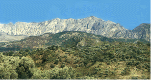
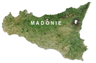
The Madonie boast Pizzo Carbonara (Carbonara Peak, formerly Pizzo della Principessa) - at 1979 meters (about 6000 feet) the highest point in Sicily after Mount Etna. Other summits in the high peaks range of the Madonie, near Carbonara Peak, include San Salvatore Mountain at 1912 meters, Mount Ferro at 1906 meters, Mount Mùfara at 1865 meters, and Corcò Peak, at 1857 meters. The snow-capped peaks are visible from Palermo in January. Eagles and hawks soar overhead. The Madonie are an extension of the Nebrodi and Peloritan mountains to the east, and with them are part of a rugged chain extending through Italy across Calabria and Sicily and then into Tunisia. To the south-west of the Madonie are the Sicanian Mountains; to the immediate south toward Enna are the Erei. Many of the towns nestled into the Madonie are of Saracen Arab foundation, dating from around the ninth century, and were subsequently developed further into larger villages under the conquering Normans. Several are ancient, built upon the remains of Sicanian, Greek and Roman settlements. The Madonie region extends, between the towns of Scillato and Castelbuono, from the Pollina to the Imera rivers, reaching down to the foothills visible from coastal Cefalù. The land itself is often wooded, and while few wild cats and no native deer remain, it is a beautiful area, especially in Winter. There are porcupines, foxes, hares, numerous birds of prey and some re-introduced deer. Among the native flora are the giant holly (some over three hundred years old), wild olives (oleasters), and the rare local variety of Madonian or Nebrodian Spruce or "Sicilian Fir" (Abies Nebrodensis), as well as the flowering Manna Ash (Fraxinus Ornus). Like many "micro-regions," the Madonie has its own cuisine, and a typically rural lifestyle. In recent
decades, emigration has depleted the population of many of the hill towns, but The "Madonie Park" is a protected reserve encompassing several townships, including Cefalù, Pollina, Castelbuono, Geraci Siculo, Petralia Soprana, Petralia Sottana, Polizzi Generosa, Sclafani Bagni, Caltavuturo and Collesano, as well as the villages of Gratteri, Isnello, San Mauro Castelverde, Scillato and Lascari. When the Normans fought several minor battles here in 1062-1063, the largest Saracen (Arab) Muslim towns were Kalat-Abi-Thur (Caltavuturo) and Petralia. The towns in the Nebrodi Mountains to the east were predominantly "Byzantine" settlements peopled by Greek Orthodox Christians before the arrival of the Arabs. About the Author: Vincenzo Mormino has written about wildlife and nature for Best of Sicily and hard-copy publications. | ||
Top of Page |
 Driving
northward in Winter along the A-19 Palermo-Catania highway (autostrada) in the stretch near Polizzi Generosa and
Caltavuturo, you pass a series of high rocky peaks usually covered with snow from late December until mid-March. It's
the highest part of the Madonie range, and it's a majestic sight.
 these scenic mountains remain
popular with residents of Palermo seeking to escape from the city for a few days. It's a favorite area for hiking. At
the Piano Battaglia resort, there's skiing for a few weeks in January and February. Indeed, these mountains are the only
area in western Sicily where snow typically lasts for more than a few days. The Tiberio Gorge, formed from limestone
erosion, on the Pollina River near San Mauro Castelverde, is one of the area's many attractions.